Pico do Areeiro to Pico Ruivo
Pico do Areeiro ao Pico Ruivo
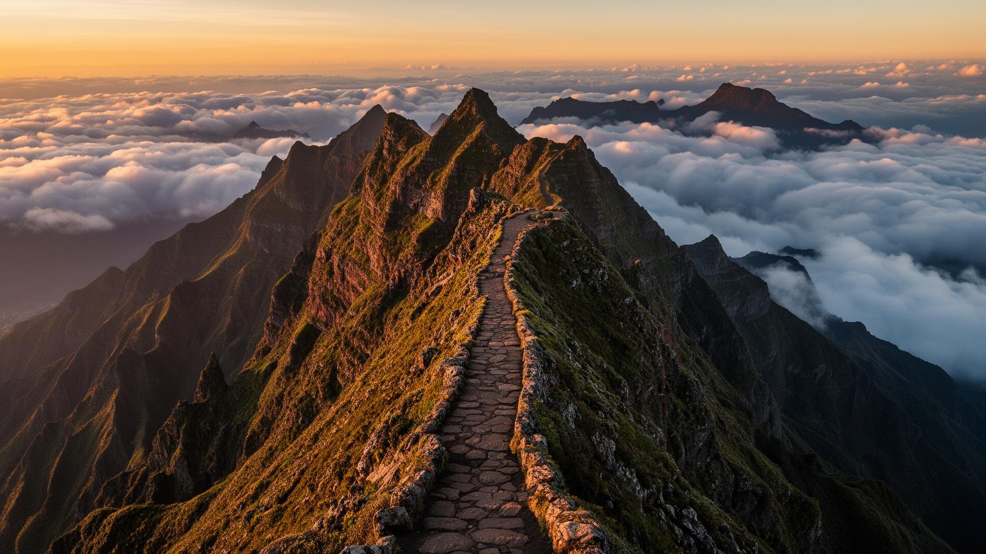
Madeira's most iconic ridge hike, connecting the island's second and highest peaks across exposed ridges, stairs and tunnels.
About Pico do Areeiro to Pico Ruivo
Pico do Areeiro to Pico Ruivo sits in the lush, north-facing slopes around Santana and is a demanding hike with exposed sections, long stair climbs and serious elevation change. Over its 7 km point-to-point route, Pico do Areeiro to Pico Ruivo climbs around 590 m of cumulative gain. Most walkers take between 4 and 5 hours, depending on pace and how often they stop for photos.
It packs a lot of variety into a relatively short distance, which is why it stays busy through the season. The route is part of Madeira's signed network of official PR ("Pequena Rota") trails, registered as PR1 in the regional PR catalogue. Markings are maintained by the forestry service, but a closure after rain or rockfall is normal — verify the day before you walk.
PR1 is the route most visitors picture when they think of Madeira hiking: a knife-edge basalt ridge above a sea of cloud, linking Pico do Areeiro (1,818 m) to Pico Ruivo (1,862 m). The full traverse is just 7 km but feels much longer — three rocky tunnels, around 1,200 stair steps in either direction, and a sustained 30–40 minute climb out of the saddle to Pico Ruivo. Most fit walkers take 3.5–5 hours one-way; doing it return is a full 8-hour day.
The classic logistics trick is to start at Areeiro at sunrise (taxi or pre-booked shuttle), walk one-way to Achada do Teixeira, and have a second taxi waiting there. This avoids the brutal climb back to Areeiro at the end of the day and lines you up perfectly with the morning's clearest weather. Booking a return shuttle costs €40–70 per group and is worth every cent.
Weather is the single biggest variable. The summit ridge sits above the trade-wind cloud layer roughly 60% of mornings between May and October — and inside it the rest of the time. If the IPMA forecast shows southerly wind or thick low-level cloud, postpone. The trail itself is safe in dry conditions but becomes genuinely dangerous in wet, icy, or zero-visibility weather; rescues from PR1 happen every year.
What to know before you go
- Trail runners are fine on dry days; switch to grippy hiking boots if rain is forecast — wet basalt is unforgiving.
- Bring more water than the distance suggests; the cumulative climb is what drains energy, not the kilometres.
- Bring a headlamp — some sections pass through unlit lava tunnels.
- Start at sunrise to beat both the heat and the cloud layer that often builds over the central ridge by late morning.
- Check the official 'Estado dos Trilhos' status before you go — trails close after storms or rockfalls.
- Headlamp is mandatory — three unlit tunnels, the longest about 200 m.
- Pre-book a taxi pickup at Achada do Teixeira before you start. Mobile coverage on the ridge is unreliable.
- Layers, not bulk: 5 °C at sunrise on Areeiro, 25 °C at Ilha by lunchtime is normal.
- The cafeteria at Pico do Areeiro opens around 09:00 — pre-dawn starters should bring breakfast.
Best time to visit
May, June, September and early October combine long daylight, stable weather and lower trail traffic. Winter is fine for the lower levadas but unreliable on the high ridges.
Location
Santana / Funchal, Madeira · Open in OpenStreetMap · Google Maps
32.73510, -16.92810
GPX track
Download a GPX file for Pico do Areeiro to Pico Ruivo to load into your watch, phone or GPS device. Always carry an offline map and follow the painted PR waymarks on the ground — GPX is a guide, not a substitute for navigation.
Download pico-areeiro-to-pico-ruivo.gpxLoading route preview…
Preview only. Map data © OpenStreetMap contributors.
Conditions log
Dated, first-person notes from people who recently walked Pico do Areeiro to Pico Ruivo. Machine-readable feed: /api/public/trail-conditions/pico-areeiro-to-pico-ruivo.
No verified reports yet for this trail. We only publish entries we can stand behind — dated, first-person, and signed. If you've walked it in the last few weeks, use the form above and we'll add it here with credit.
Frequently asked
How hard is the PR1 Pico do Areeiro to Pico Ruivo hike?+
Hard. About 7 km one-way with 590 m of cumulative ascent, exposed ridges, stairs and tunnels. Allow 4 hours plus a return option.
Do you need a headlamp for PR1?+
Yes — the route passes through several unlit tunnels. A phone torch works in a pinch but a real headlamp is safer.
Can you do PR1 one-way?+
Yes — most hikers pre-book a transfer from Pico Ruivo / Achada do Teixeira back to Pico do Areeiro.
How long does the Pico do Areeiro to Pico Ruivo hike take?+
Most hikers complete Pico do Areeiro to Pico Ruivo in around 4 hours, though slower paces or photo stops can push it to 6 hours. The route is 7 km long with about 590 m of elevation gain.
Is Pico do Areeiro to Pico Ruivo suitable for beginners?+
Pico do Areeiro to Pico Ruivo is rated hard and is not recommended as a first Madeira hike. It involves steep stairs, exposed ridges and serious elevation change. Build up to it on easier levada walks first.
Do I need a guide for Pico do Areeiro to Pico Ruivo?+
No, Pico do Areeiro to Pico Ruivo is a signed official trail and most fit hikers walk it independently. Local guides are widely available if you prefer transport, route certainty, or commentary on the landscape.
Can I walk PR1 in one direction only?+
Yes, and most experienced hikers do. The standard direction is Areeiro → Ruivo → Achada do Teixeira, which is mostly downhill in the final third. Arrange a taxi at Achada beforehand.
When does PR1 close?+
PR1 closes after storms, rockfalls, snow and high wind. Closures are common in winter and after any heavy rain. Always check 'Estado dos Trilhos' on visitmadeira.pt within 24 h of your hike.
Nearby on Madeira
Other places within easy reach of Pico do Areeiro to Pico Ruivo.