Levada do Caldeirão Verde
A classic laurel-forest levada walk from Queimadas to a tall waterfall in a green amphitheatre. Mostly flat with several tunnels — bring a headlamp.
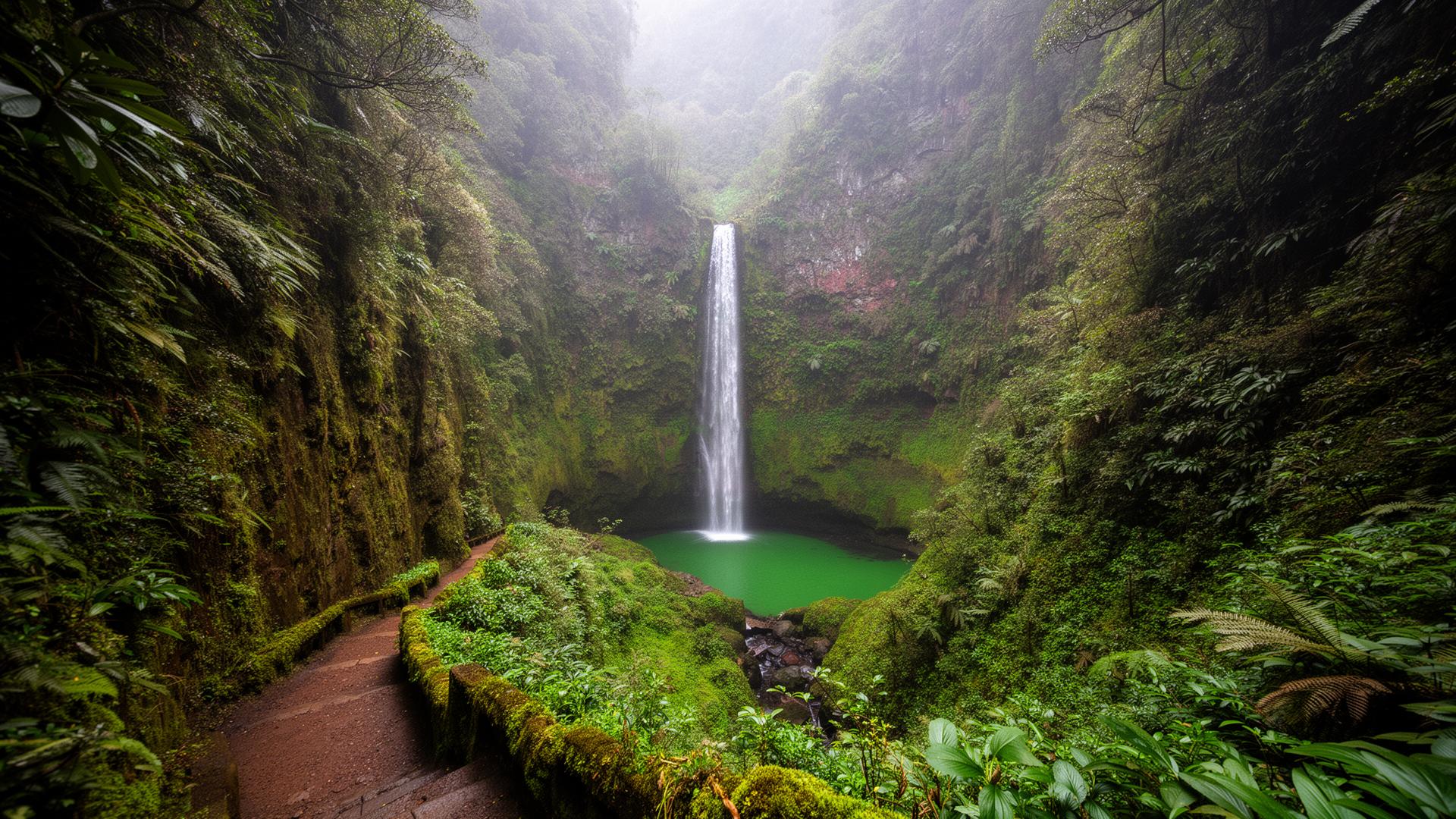
About Levada do Caldeirão Verde
Levada do Caldeirão Verde sits in the lush, north-facing slopes around Santana and is a moderately demanding hike — good fitness helps but no technical skills required. Over its 13 km point-to-point route, Levada do Caldeirão Verde climbs around 150 m of cumulative gain. Most walkers take between 5 and 6 hours, depending on pace and how often they stop for photos.
Bring more water than you think you need and pace yourself — the second half is where most people struggle. The route is part of Madeira's signed network of official PR ("Pequena Rota") trails, catalogued as PR9. The PR sign at the trailhead is your reassurance, not a promise — weather on the central ridge can shift inside an hour.
PR9 is the levada walk people remember years later. It follows the Levada do Caldeirão Verde 6.5 km up a steep laurisilva valley from Queimadas, passing four hand-cut tunnels (the longest about 180 m) before opening into a natural amphitheatre where a thin 100 m waterfall drops into a green pool. Total round trip is 13 km, almost flat — the channel itself has just 0.5% gradient — but you're walking with a sheer drop on one side for much of the way.
The trail starts at Parque das Queimadas, an A-frame thatched-roof cottage compound at 880 m altitude that is worth a few minutes on its own. Parking fills by 09:30 in summer; the access road is narrow and unpleasant to reverse along, so arrive early or come by booked transfer.
What to know before you go
- Wear proper hiking shoes with grip — basalt gets slippery when damp, and most levada paths have a drop on one side.
- Pack two litres of water per person — there are no refill points on the route — and a light fleece for the ridge wind.
- Bring a headlamp — some sections pass through unlit lava tunnels.
- Mid-morning is fine, but earlier starts mean clearer views and emptier paths.
- Check the official 'Estado dos Trilhos' status before you go — trails close after storms or rockfalls.
- Headlamp essential — four tunnels, no lighting.
- Path is 80 cm wide in places with a 50 m drop. Not suitable for nervous walkers or young children.
- Combine with PR9.1 (Caldeirão do Inferno) for a longer day, but only in dry conditions — the extension is more exposed.
Best time to visit
May, June, September and early October combine long daylight, stable weather and lower trail traffic. Winter is fine for the lower levadas but unreliable on the high ridges.
Location
Santana, Madeira · Open in OpenStreetMap · Google Maps
32.78441, -16.90567
GPX track
Download a GPX file for Levada do Caldeirão Verde to load into your watch, phone or GPS device. Always carry an offline map and follow the painted PR waymarks on the ground — GPX is a guide, not a substitute for navigation.
Download levada-do-caldeirao-verde.gpxLoading route preview…
Preview only. Map data © OpenStreetMap contributors.
Conditions log
Dated, first-person notes from people who recently walked Levada do Caldeirão Verde. Machine-readable feed: /api/public/trail-conditions/levada-do-caldeirao-verde.
No verified reports yet for this trail. We only publish entries we can stand behind — dated, first-person, and signed. If you've walked it in the last few weeks, use the form above and we'll add it here with credit.
Frequently asked
Is Caldeirão Verde suitable for beginners?+
It is mostly flat but long (13 km return) with narrow paths beside the levada and four tunnels. Reasonable fitness and a headlamp are needed.
How long does the Levada do Caldeirão Verde hike take?+
Most hikers complete Levada do Caldeirão Verde in around 5 hours, though slower paces or photo stops can push it to 7 hours. The route is 13 km long with about 150 m of elevation gain.
Is Levada do Caldeirão Verde suitable for beginners?+
Levada do Caldeirão Verde is rated moderate. Beginners with reasonable fitness can complete it, but expect uneven ground, some exposed sections and a few hours on your feet.
Do I need a guide for Levada do Caldeirão Verde?+
No, Levada do Caldeirão Verde is a signed official trail and most fit hikers walk it independently. Local guides are widely available if you prefer transport, route certainty, or commentary on the landscape.
Is Caldeirão Verde dangerous?+
It is safe when respected — but the unfenced drop on the downhill side is real, and slips on wet basalt cause most accidents. Stay on the inside of the path, do not overtake on narrow sections, and turn back in heavy rain.
Nearby on Madeira
Other places within easy reach of Levada do Caldeirão Verde.